

Spatial Data Science
.jpg)
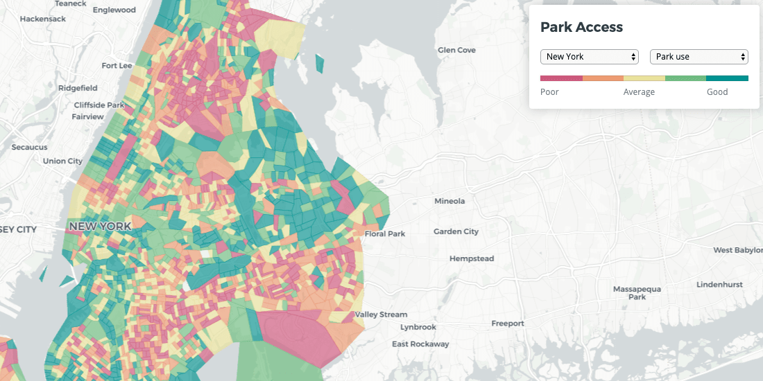

Quantifying Park Use in American Cities: Spatial Models and Novel Measures
Learn how cities can use spatial modeling to more accurately assess park use to inform planning and facilities decisions


Magnify your Analysis: Statistical Downscaling to Enhance Spatial Resolution
From understanding the dynamics of a business, to modelling physical and biological processes, selecting the proper spatial scale matters.


Spatial Analysis: Private Equity's Secret Weapon
Which types of funds invest in spatial analysis? How do they use location data in screening & portfolio management? We discuss the role of Data Science.


PostGIS Day: A future, post GIS
Is GIS dead? No, but it is undergoing a transformation - and we're excited to see how spatial analysis can continue to change our world.

Retail Revenue Prediction Models with Spatial Data Science
Predicting store revenues is critical, allowing retail leaders to stay agile, make informed decisions around current store operations, and plan the most effective new openings. The most accurate prediction models include the location component.


On-demand last mile transportation: Real-time route optimization with Location Intelligence
Discover how spatial analysis enhances last-mile transportation, optimizing routes for efficiency and reducing costs in delivery logistics.

Improving Healthcare Access with Spatial Data Models
An investigation of healthcare access across America, built on new spatial data science techniques

Big Data from Space: Using CartoDB to track environmental change
Discover the stories behind environmental data with CARTO. Explore deforestation trends, visualize Big Data insights, and unlock spatial analysis.
Faster data updates with CartoDB
Optimize your CartoDB tables with efficient batch updates. Learn to enhance SQL queries for faster inserts, reducing table scans. Boost app performance!
CartoDB Migration Complete, Welcome to 2.0
Explore CartoDB 2.0 migration: enhanced spatial data visualization, improved performance, upcoming features. Share your feedback with the community.

Academy


CARTO & Snowflake: Location Intelligence for Energy and Utilities
CARTO and Snowflake expanding cloud-native Location Intelligence for Energy and Utility organizations, unifying IoT data for resilient operations.
Nagarro & CARTO: Advancing Enterprise AI Transformation
CARTO and Nagarro partner to help enterprises move AI from pilots to production, embedding Location Intelligence into existing workflows and systems.


Unlock trade-area analysis at scale with H3 Isochrones
Scale travel-time analysis with H3-based isochrones in CARTO. Faster joins, overlap insights, and 96–99% time savings powered by TravelTime.