


CARTO & Snowflake: Location Intelligence for Energy and Utilities
CARTO and Snowflake expanding cloud-native Location Intelligence for Energy and Utility organizations, unifying IoT data for resilient operations.

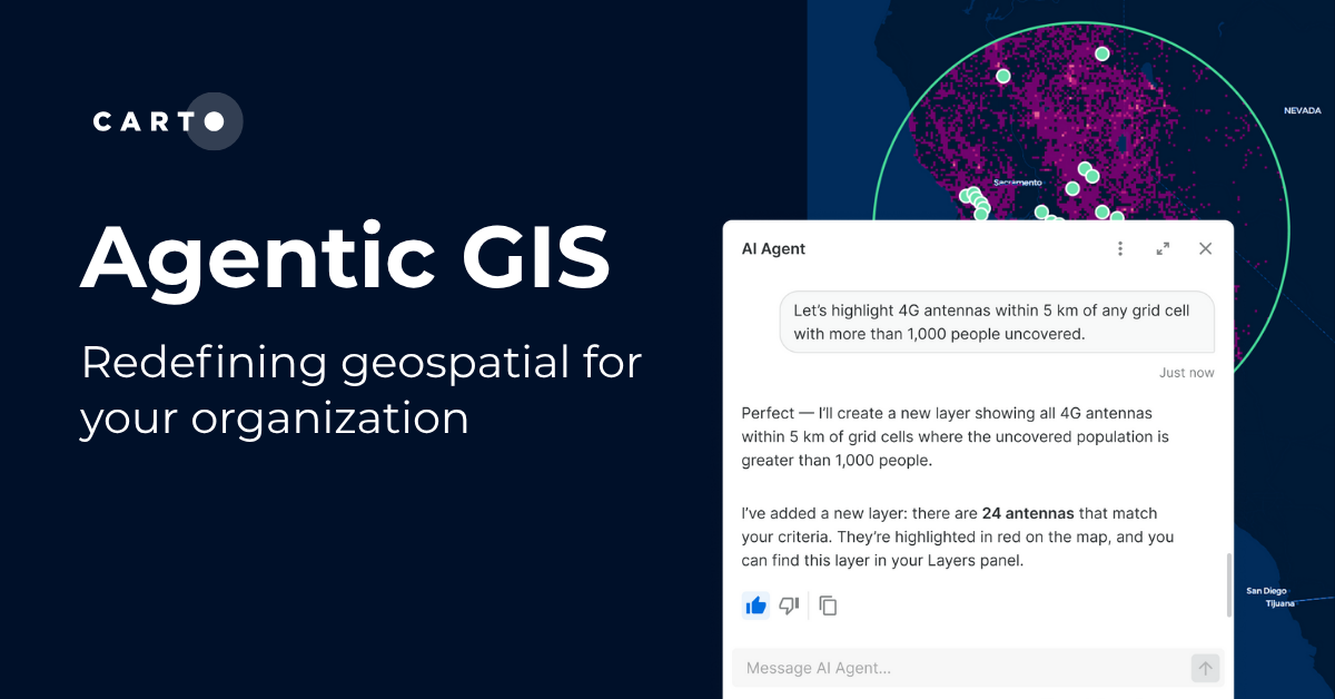


Agentic GIS has landed: redefining geospatial for your organization
Discover how CARTO’s Agentic GIS platform and AI Agents are transforming spatial analysis - making Location Intelligence accessible to everyone.
What’s new in CARTO - Q3 2025
Discover CARTO’s Q3 2025 updates: smarter workflows, better governance, easier imports & new tools for territory planning.
.png)

CARTO's Territory Planning tools for better location decisions
Optimize your strategy with CARTO's Territory Planning Extension! Enable smarter location decisions, balancing territories & improving logistics for efficiency and growth.
.png)

.jpg)
Navigate consumer demand with NIQ Purchasing Power Data
Navigate consumer demand with NIQ Purchasing Power Data. Understand consumer spending, optimize location planning, and boost marketing.
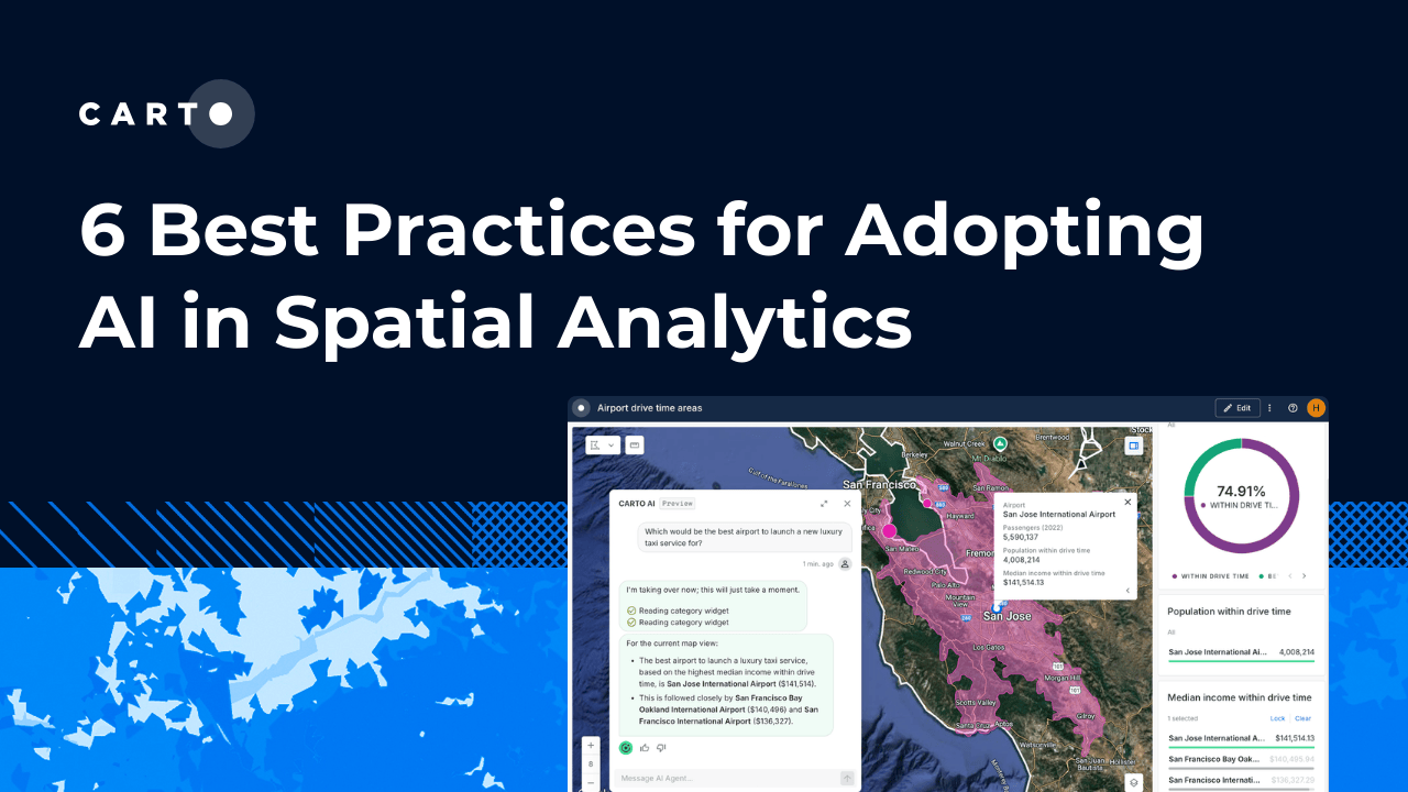

6 best practices for adopting AI in Spatial Analytics
Learn 6 best practices for integrating AI into spatial analytics. Establish a secure, scalable AI strategy to automate tasks and make confident decisions.
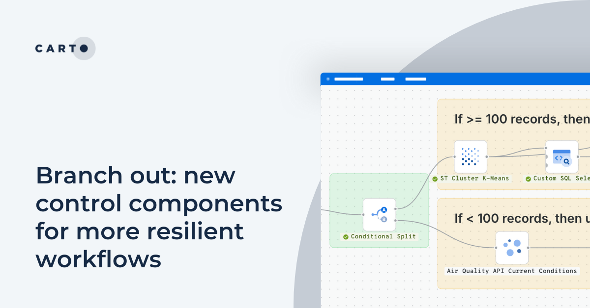
Branch out: new control components for more resilient workflows
Discover CARTO Workflows’ new Conditional & Success/Error Split components to build flexible, resilient spatial analysis pipelines.
.png)
From Imagery to Insight: Google AlphaEarth Foundations in CARTO
Discover how CARTO integrates Google DeepMind’s AlphaEarth satellite embeddings for advanced geospatial AI, climate, and risk analysis.
.png)
5 ways to transform spatial analysis for environmental resilience
Discover 5 ways to transform spatial analysis for environmental resilience using cloud-native GIS, automation, and real-time insights.
.png)

Cotality’s Location Intelligence Insights - now in CARTO
Explore Cotality’s US Location Intelligence data in CARTO - now available via Data Observatory for fast, actionable spatial insights at scale.
.png)
What’s New in CARTO - Q2 2025
Discover CARTO's Q2 2025 updates - new features for smarter maps, team collaboration, automation, and scalable spatial analysis in the cloud.
.png)
Create your expansion strategy with CARTO and Snowflake
Learn how CARTO and Snowflake help you build a winning expansion strategy. Pinpoint ideal locations, leverage spatial analytics & AI for confident growth.
.png)

.jpg)
Pain-free data integration with Overture Maps, GERS & Databricks
Seamlessly integrate spatial data with Overture Maps, GERS & Databricks for fast, scalable geospatial analysis - no ETL or data wrangling needed.

Academy
CARTO & Snowflake: Location Intelligence for Energy and Utilities
CARTO and Snowflake expanding cloud-native Location Intelligence for Energy and Utility organizations, unifying IoT data for resilient operations.
Nagarro & CARTO: Advancing Enterprise AI Transformation
CARTO and Nagarro partner to help enterprises move AI from pilots to production, embedding Location Intelligence into existing workflows and systems.


Unlock trade-area analysis at scale with H3 Isochrones
Scale travel-time analysis with H3-based isochrones in CARTO. Faster joins, overlap insights, and 96–99% time savings powered by TravelTime.

