


CARTO & Snowflake: Location Intelligence for Energy and Utilities
CARTO and Snowflake expanding cloud-native Location Intelligence for Energy and Utility organizations, unifying IoT data for resilient operations.


Agricultural Sustainability with CARTO, Indigo Ag, & Snowflake
With our platform & Snowflake connector, read how Indigo Ag rapidly gathers, styles, & shares insights from spatial models improving agricultural sustainability


#SDSC21: Financial Services Summit Agenda Now Available
Sign up for talks from JPMorgan, Goldman Sachs, Bloomberg, Swiss Re, Signal Capital, Willis Towers Watson, Jefferies, PicPay, Cifas, BBVA, Google, & Safegraph


How Google Cloud & CARTO power geospatial analysis at scale
Discover how to scale your analytical workflow & access massive geospatial datasets with Google Cloud & CARTO & the general availability of BigQuery Tiler

COVID Vaccine: Mapping Rollout & Optimizing Supply Chain
As COVID vaccines become more widely available we look maps analyzing the rollout & supply chain optimization for an efficient & equitable immunization strategy


How to Enrich POS Data to Analyze & Predict CPG Sales
Learn how to enrich & perform spatial modeling on retail point of sale data to analyze CPG sales & predict future performance in new locations


Foursquare POI & Foot Traffic Data now available in CARTO
We are pleased to announce our partnership with Foursquare, leaders in location technology, & the inclusion of its POI & foot traffic data in our Data Observatory

Announcing #SDSC21: A Series of Spatial Data Science Events
Following the success of #SDSC20 we're excited to announce 2021's online edition of the Spatial Data Science Conference plus 2 more industry specific events

Announcing CARTO BigQuery Tiler General Availability
We are excited to announce the general availability of CARTO BigQuery Tiler, a unique solution for visualizing massive spatial datasets hosted in Google BigQuery


Agritech & Spatial Data: Predicting Crop Yield in Agriculture
Read how our partner NGIS built a spatial web application, CroppingHub, to detect crop types & predict crop yield using cloud computing & machine learning

How to Improve Retail Trade Area Accuracy with Mobility Data
Read how to improve retail trade area accuracy by moving beyond buffers & drive times to using spatial analysis & human mobility data

3 Spatial Data Science Trends to Watch in 2021
Geography is changing faster than ever before. Read our predictions for the key Spatial Data Science trends & industries to watch in 2021.
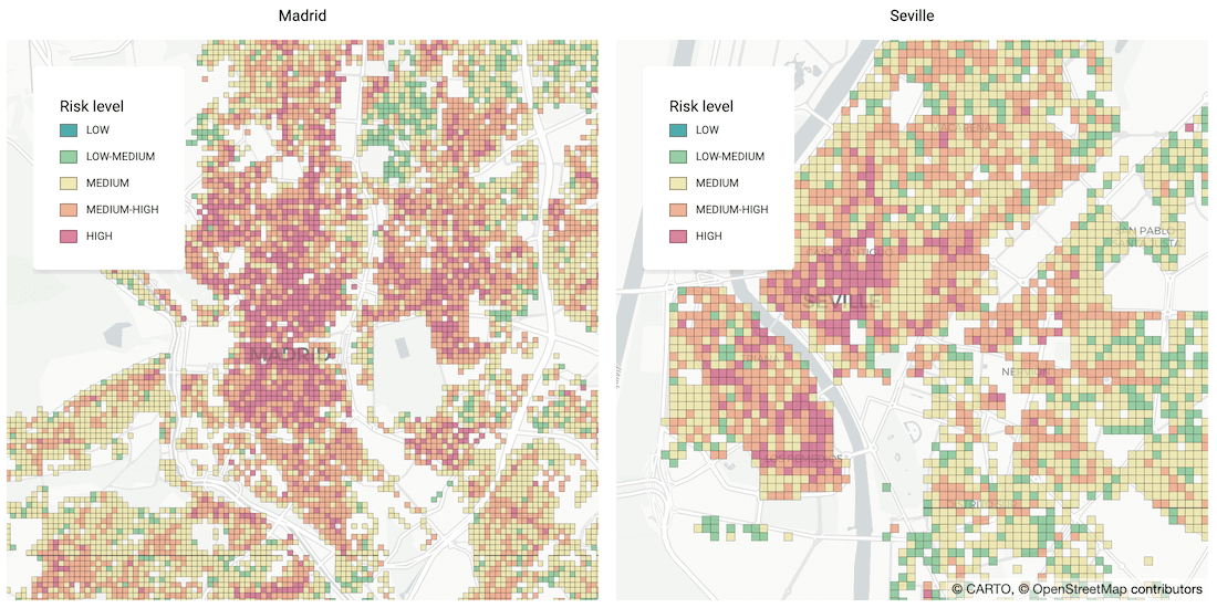

Identifying Areas Most Likely to Suffer Recession Post Pandemic
As many parts of the world enter into recession following the Coronavirus pandemic, read how Spatial Data Science can help identify areas with a greater risk

Academy
CARTO & Snowflake: Location Intelligence for Energy and Utilities
CARTO and Snowflake expanding cloud-native Location Intelligence for Energy and Utility organizations, unifying IoT data for resilient operations.
Nagarro & CARTO: Advancing Enterprise AI Transformation
CARTO and Nagarro partner to help enterprises move AI from pilots to production, embedding Location Intelligence into existing workflows and systems.


Unlock trade-area analysis at scale with H3 Isochrones
Scale travel-time analysis with H3-based isochrones in CARTO. Faster joins, overlap insights, and 96–99% time savings powered by TravelTime.

