What's new in CARTO - Q2 2026



AI has changed how teams work with software, forever. Tasks that once required specialized tools, months of training, or engineering support can now start with a conversation. Teams describe what they need and coding agents help build the analysis to get there.
Geospatial is no exception. With the right AI tools, analysts can now build advanced spatial workflows and maps faster than ever, get up and running on the CARTO platform in hours, and spend more time on the questions and strategy that drive the organization forward.
That's exactly what we're building at CARTO to unlock Agentic GIS for the enterprise. In Q2, we launched new capabilities that bring CARTO into the coding agents and AI tools teams already use every day. Analysts can now build more advanced spatial analytics than ever before. Coding agents create Builder maps, configure Workflows, and even develop entire custom spatial applications. That frees analysts to focus on understanding the data, asking better questions, and getting to answers faster.
Additionally, in these last months we have continued evolving our platform to meet the requirements of modern teams working on GIS at scale. Users can now better organize their assets into projects and folders within the CARTO Workspace, we have added support for grouping map layers in Builder, added version history control in CARTO Workflows, and much more.
Let's now take a look at the highlights from this quarter's CARTO release - and remember to keep an eye on our What's New page for the latest updates.
Agentic GIS
Boost team productivity with CARTO for Agents
Helps you to: Build maps, run spatial analysis, and automate geospatial workflows alongside agents using the AI tools teams already use day-to-day.
CARTO for Agents is one of our biggest releases this year. It brings the full CARTO platform into the AI workflows enterprise teams are adopting across their organizations, including Claude, ChatGPT, Codex, Cursor, Copilot, and other MCP-compatible platforms.
With CARTO for Agents, users can work with AI agents to:
- Build and modify CARTO Builder maps
- Create and manage Workflows
- Discover datasets in the Data Observatory
- Run spatial analysis
- Build custom geospatial applications
- Manage platform resources
Users describe the outcome they need in plain language. AI agents alongside analysts, advise and help build advanced maps, workflows, and analysis to answer business questions faster.
CARTO for Agents includes 3 key capabilities:
- CARTO CLI: A script-friendly command-line interface that allows users and AI agents to interact with the CARTO platform programmatically.
- CARTO MCP Server: A hosted Model Context Protocol (MCP) server that connects CARTO capabilities with AI clients including Claude, ChatGPT, and Gemini.
- CARTO Agent Skills: A public collection of skill playbooks that helps AI agents work with CARTO more effectively.
Together, these capabilities help teams bring spatial analysis into the AI tools they already use, so analysts spend less time on repetitive setup and more time on the work that matters.
Learn more about CARTO for Agents in our announcement, explore how to build maps through prompts, see how coding agents can design and validate spatial workflows, or discover how developers can create spatial applications faster with AI.
Track and audit how AI Agents reach their answers
Helps you to: Inspect the steps an AI Agent takes to complete a task, so your team can validate results and build confidence in AI-generated outputs in development and production.
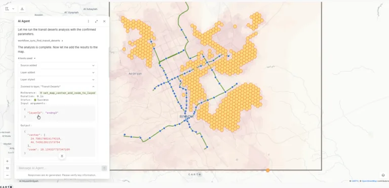
As agents become part of everyday spatial workflows, understanding what they actually do is essential. New tool traceability gives users full visibility into how an Agent completes a task. For every conversation, teams can now see the tools executed, the parameters passed to each tool, the outputs returned, the SQL generated during query execution, and the inputs used by Workflow MCP tools.
That transparency helps teams validate results, catch errors early, and understand how agents generate their responses.
Learn more about AI Agent tools in our documentation.
Connect to your preferred AI infrastructure
Helps you to: Use CARTO's AI capabilities with the AI providers and infrastructure your organization already manages.
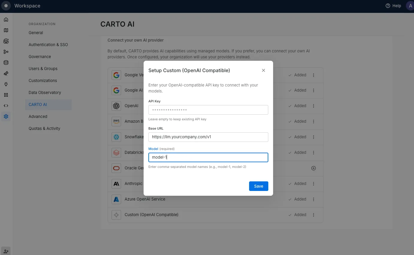
CARTO supports leading AI providers including Google Vertex AI, OpenAI, Anthropic, AWS Bedrock, Azure OpenAI, Snowflake, Databricks, and Oracle. Organizations can now also connect any OpenAI-compatible endpoint, including custom gateways, proxy layers, and self-hosted models. Connected providers can power AI Agents, the Agent Configuration Assistant, the AI Assistant in Data Observatory, and any of the upcoming AI features in CARTO.
This gives teams more flexibility to align CARTO AI with their existing technology environment rather than working around it.
Learn more in the CARTO AI settings documentation.
Stay up-to-date with the latest AI models
Helps you to: Take advantage of the latest AI capabilities while continuing to use the providers and infrastructure that fit your organization.
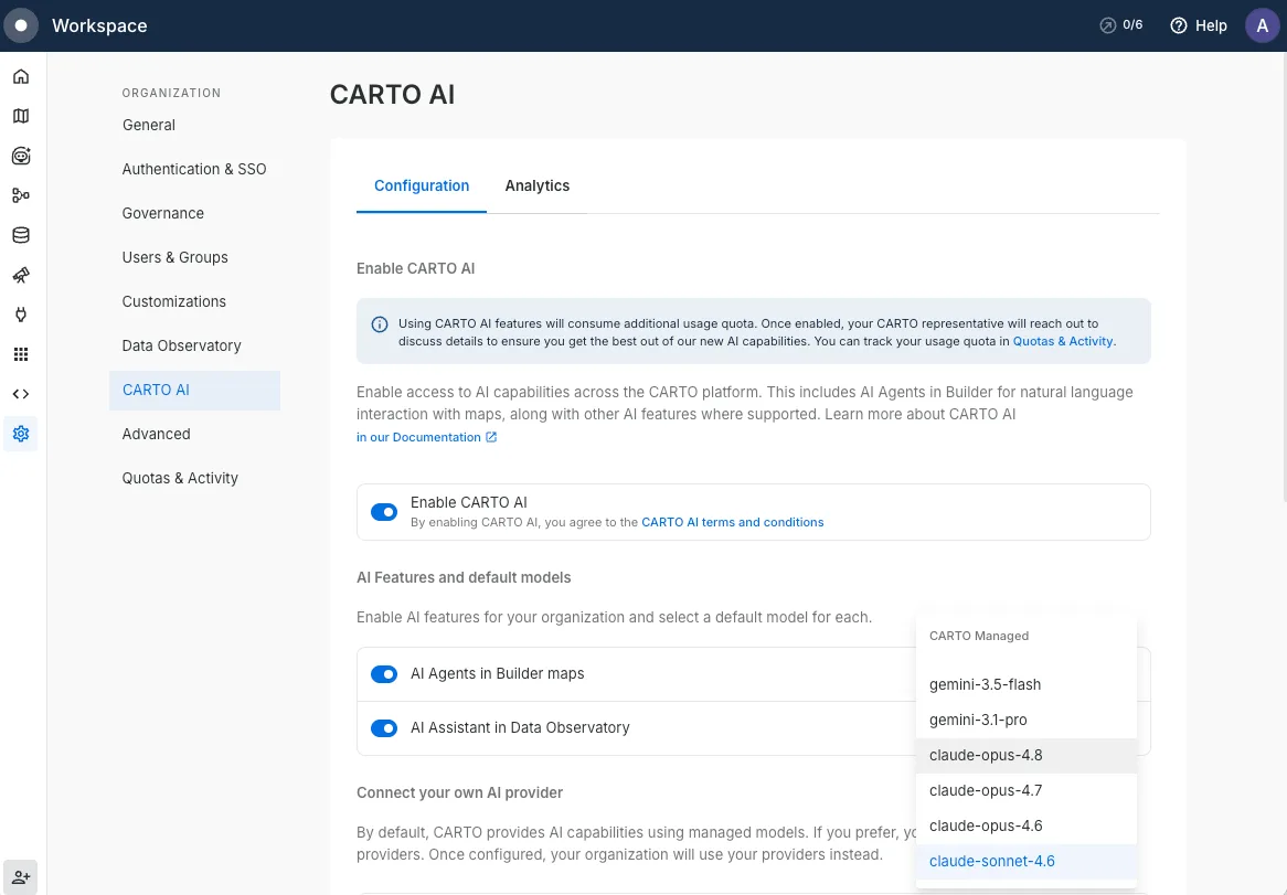
CARTO AI now supports the latest generation of models across every supported AI provider, giving teams access to improved reasoning, faster responses, and higher-quality results for geospatial analysis.
Whether you use CARTO-managed models or bring your own AI provider, in a matter of a couple of days since their release you can take advantage of the newest models from OpenAI, Anthropic, Google Gemini, xAI, and more across CARTO's AI features.
As new models become available, you can benefit from the latest AI capabilities without changing your existing workflows or infrastructure.
Learn more in the CARTO AI settings documentation.
Data & Analytics
Workflow version history
Helps you to: Manage changes and collaborate confidently on Workflows, without the risk of losing a working version.
Workflows now maintain a complete version history automatically.
Teams can review previous versions, search and filter Workflow history, preview earlier states, restore a previous version, or duplicate a Workflow from any historical snapshot. Published versions stay stable for consumers while editors continue making improvements in the background.
Learn more about Version History.
New Advanced Analytics Toolbox functions for Oracle and Databricks
Helps you to: Run advanced spatial analysis directly where your data lives, without moving it.
We expanded the Analytics Toolbox across cloud data platforms with new capabilities for Oracle and Databricks.
For Oracle Autonomous Database, the latest release adds data enrichment functions including ENRICH_POLYGONS along with full H3 and Quadbin spatial indexing support. Explore and see the full reference list.
For Databricks, new capabilities include HOTSPOT_ANALYSIS for identifying spatial patterns using Getis-Ord Gi* statistics, and data enrichment functions for spatial datasets. Explore and see the full reference list.
Both updates help teams run advanced spatial analysis directly in their cloud data environment rather than extracting and transforming data elsewhere first.
Learn more about the Analytics Toolbox for Oracle and Analytics Toolbox for Databricks.
Visualization & App Development
More ways to create maps and explore data in Builder
Helps you to: Create richer, more intuitive maps that are easier to build, navigate, and share.
Q2 introduced several improvements across Builder that make it easier to create polished visualizations and manage increasingly complex projects:
- Layer groups: Large maps are easier to organize with new collapsible layer groups. Related datasets can be grouped together, helping users keep projects organized, simplify navigation, and present complex analyses more clearly. Learn more.
- Google Photorealistic 3D Tiles: CARTO Builder now supports Google Photorealistic 3D Tiles. Your data appears in real-world 3D context automatically, which is particularly useful for urban planning, real estate analysis, and insurance risk assessment. Learn more.
- Custom SQL aggregation expressions: Spatial index layers and aggregated-by-geometry layers now support custom SQL aggregation expressions, making it easier to calculate derived metrics such as rates, ratios, and weighted averages. Learn more.
- Labels for polygon and line layers: Text labels are now available for polygon and line layers, making it easier to identify administrative boundaries, roads, utilities, and other geographic features. Builder automatically places each label for optimal readability, helping teams create cleaner maps with less manual effort. Learn more.
Learn more about Builder dashboards.
Enterprise & Governance
Organize your maps and workflows with projects and folders
Helps you to: Bring structure to your workspace, group maps and workflows by team, client, or use case instead of scrolling one long list.
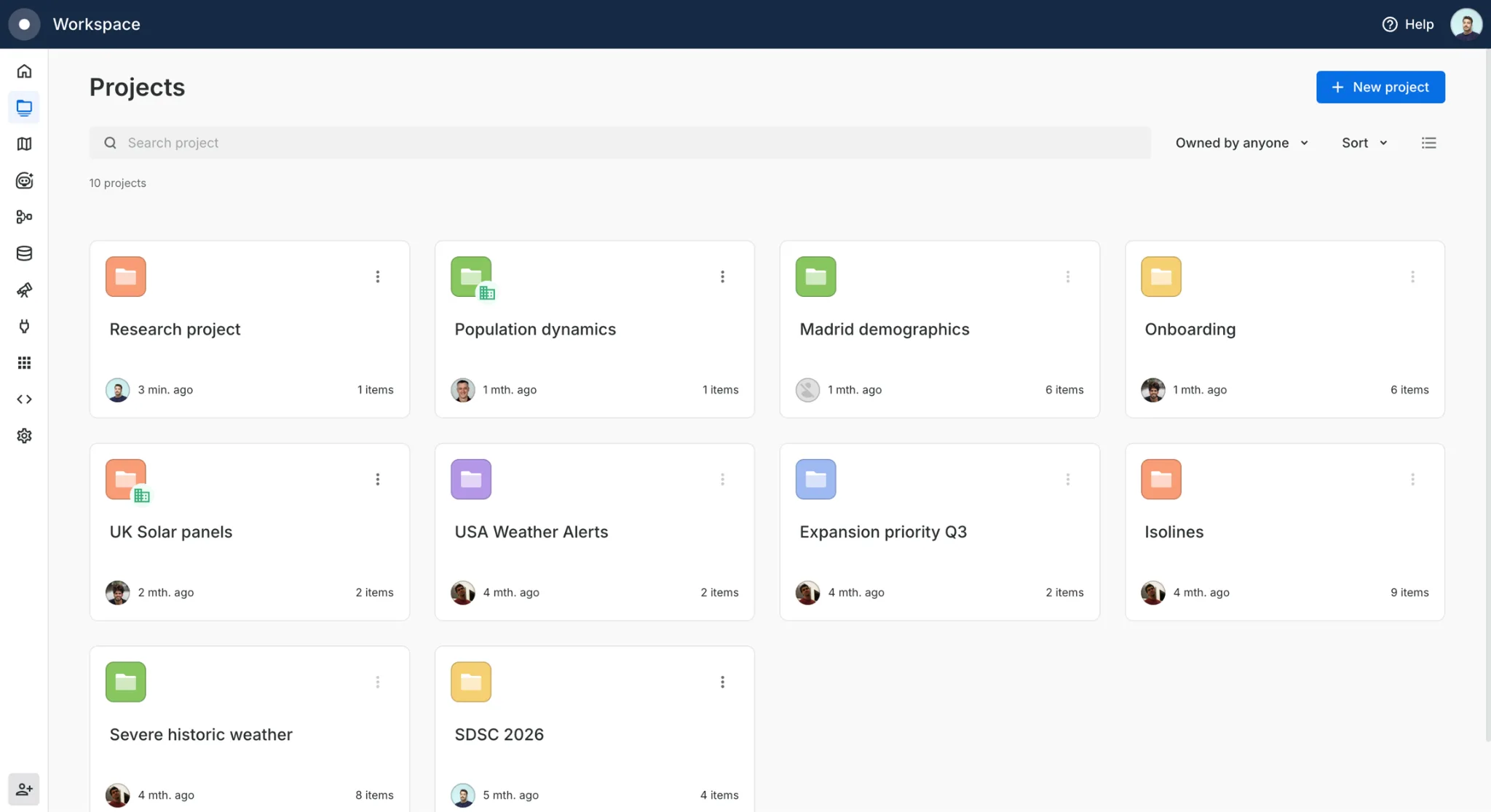
Users can now organize their assets into projects and folders within the CARTO Workspace. Group related work together, nest folders as deep as you need, and move or create assets associated to the projects they belong.
Projects keep your Workspace tidy and make collaboration easier: share a project or folder once and everything inside inherits that access, so you set permissions in one place instead of asset by asset. When the same map or workflow belongs in more than one project, add a shortcut instead of moving it.
Learn more about Projects.
Manage CARTO AI usage with enterprise-grade controls
Helps you to: Give administrators the visibility and controls they need to govern AI usage as adoption grows.
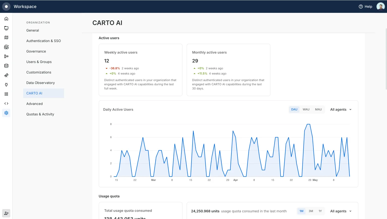
As more teams adopt agents and AI workflows, teams need clear controls and a clear picture of what's happening. In Q2, we introduced new tools for managing CARTO AI at the organizational level. CARTO Admins can now enable individual AI features and configure default models for each capability separately.
Our new dedicated Analytics tab in the Settings > CARTO AI gives usage visibility across CARTO AI Agents, external agents connected through MCP Server, and overall AI consumption.
Quota management also allows admins to define usage limits for users and groups across Usage, Location Data Services, and AI quotas for added controls to help organizations adopt AI responsibly while maintaining the oversight needed to do so confidently.
Learn more in our CARTO AI Analytics documentation.
Track your highest performing maps and workflows by usage
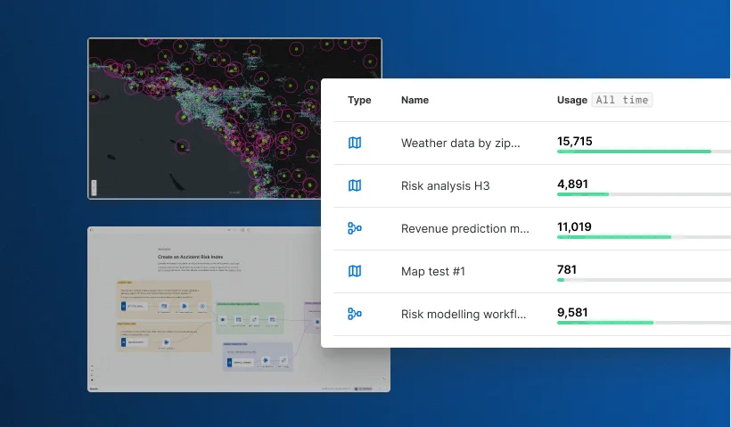
Helps you to: Understand where platform usage is coming from, down to the asset level.
CARTO Admins can now see which specific maps and workflows are consuming Usage Quota. Activity Data exports now include map and Workflow identifiers, making it easier to identify high-consumption assets, understand usage patterns, and connect platform activity back to teams and projects.
Learn more about Activity Data reference.
More flexible API Access Token management
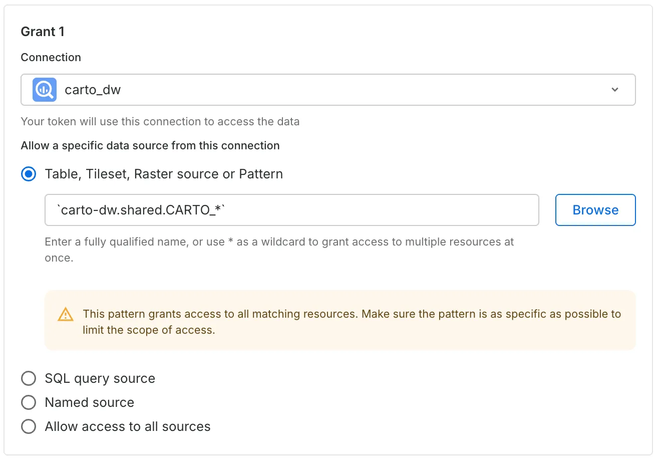
Helps you to: Manage access permissions across groups of data assets without maintaining long manual lists.
API Access Tokens now accept wildcard patterns for table, tileset, raster source, and pattern grants. Teams can use patterns to manage access across groups of assets rather than listing resources individually, which becomes increasingly useful as new data resources are added over time.
Learn more in our API Access Tokens documentation.
—
That's Q2 2026! This quarter marked a major milestone in our Agentic GIS journey, bringing Location Intelligence into the AI tools, coding assistants, and chat agents teams already use to build, analyze, and make decisions.
Alongside new governance capabilities, usage visibility, and analytics enhancements, these releases make it easier for organizations to adopt AI and scale spatial analysis with confidence. From building maps through natural language to running advanced analytics directly in cloud data platforms, CARTO continues to make geospatial analysis and insights more accessible, flexible, and enterprise-ready.
To keep up with the latest releases, visit the What's New page of our Documentation and follow us on LinkedIn for live updates, or sign up for our newsletter to get highlights straight to your inbox.
Want to sharpen your skills? Explore hands-on tutorials in CARTO Academy. Not a CARTO user yet? Start for free and experience these new features yourself!