What is Agentic GIS?


The GIS industry is undergoing its most significant transformation since the shift from desktop to cloud, one that will be even bigger in scope and impact. The rise of Agentic AI - AI systems capable of reasoning, taking actions, and orchestrating tools to solve complex tasks - is redefining how organizations work with geospatial data in a shift now being referred to as Agentic GIS.
For decades, spatial analysis has been driven by GIS experts operating specialized tools, responding to questions from across the business: Where should we invest? What’s changing in this region? How do we plan more efficiently? But the workflows behind these answers - gathering data, building models and maps, validating results - are complex and iterative. They don’t translate easily into self-service dashboards or reusable tools.
Agentic GIS is the evolution where geospatial analysis is no longer limited by software complexity, specialized tools, or domain silos. Instead, analytical workflows become interactive, intelligent, and accessible across the enterprise. They are powered by AI agents that understand spatial questions and can autonomously run and adapt tools in a loop until reaching an answer.
In this blog post, we will reflect on what Agentic GIS means, what we see as its main pillars, and where it's going to take us as an industry.
Here's the thing about spatial analysis: it's almost never just one question - and those questions rarely have one straightforward answer. Spatial analysis is inherently multi-step, visual and contextual. A question like “Where should we open our next store?” isn’t a single query - it’s a chain of reasoning that adapts as more context comes to light. The answer requires understanding existing store performance, competitive presence, demographics, mobility patterns, accessibility, zoning considerations, and even seasonal behaviors.
Traditionally, GIS professionals guide this process manually and in isolation from those who need to actually make a decision. The GIS expert selects datasets, runs sequential analyses, validates outputs, visualizes results, and finally packages insights for decision-makers. Any changes to this process required by the decision-maker may mean starting over. This work is valuable - but it can be time-consuming and inflexible - and it scales only as fast as GIS teams can respond.
Agentic AI is well-suited to the more dynamic and flexible reasoning process that decision-makers require. Agentic GIS systems can choose the right tools and data, check intermediate results, refine their approach, and iterate until the answer is grounded and meaningful. It’s similar to what’s happening in software engineering with tools like Claude Code: they don’t replace developers, but dramatically boost their productivity by handling the mechanical steps, so engineers can stay focused on architecture and higher-order problem-solving. Agentic GIS follows the same pattern. The logic shifts from “assemble map layers and workflows” to “understand the question and reason through it.”
This doesn’t remove the GIS expert - it amplifies them. GIS professionals define the guardrails, data sources, validation rules, and domain context. Business users then explore spatial questions in natural language, while the agent handles the analytical steps behind the scenes.
The result is a shift in interaction: less time spent configuring layers, filters, and styles - and more time focused on the question, the reasoning, and the decision that follows.
During the last few years the entire geospatial industry has been looking into how Geospatial AI could enhance GIS workflows, but only now have all the necessary foundations aligned.
First, AI models have advanced significantly. The latest generation of frontier models (like GPT-5, Claude 4.5, Gemini 2.5) can use tools, reason through multi-step problems, and interpret complex inputs - including spatial data and analytical logic. They don’t just generate text; they can think through a spatial question.
Equally important is the emergence of Feedback Loop Agents. These agents evaluate and refine their own outputs - an essential capability in GIS, where insight often requires iterative validation. They can re-run an analysis when something looks off, ask for clarification when data lacks context, and adjust methods to produce results that are geographically sound.
We are also seeing the rise of standards for agent orchestration, such as Model Context Protocol (MCP) and Agent-to-Agent (A2A), enabling consistent communication between agents, tools, and data systems. This means AI agents are no longer isolated assistants - they can participate in full analytical workflows, leveraging different systems to perform their operations and being accessed from multiple channels.
And finally, the shift to cloud-native spatial infrastructure has removed one of GIS’s biggest barriers. With platforms like CARTO running directly in cloud data lakehouses (such as BigQuery, Oracle, Snowflake and Databricks), spatial data is no longer siloed - making it accessible, scalable, and secure for AI-driven workflows.
In short, the models are ready, the orchestration layer is here, and the geospatial data foundation has finally matured enough to enable the application of Agentic GIS at the enterprise organization level.
AI Agents make geospatial insights more broadly accessible. Business users can ask questions in natural language and receive clear, map-backed answers - without needing to understand spatial SQL, projections, enrichments, or analysis workflows. GIS professionals define how the agent should reason: which datasets to trust, how to validate results, and how to interpret outcomes. In doing so, they encode their geospatial expertise into reusable reasoning patterns. The result is not just wider access to maps, but wider access to spatial insights across the organization.
AI Assistants and co-pilot experiences boost the productivity of the GIS analysts. AI becomes a collaborator, drafting spatial SQL queries, summarizing datasets, assisting on the design of geospatial workflows, creating and styling layers, etc. This not only reduces the skill barrier to advanced spatial analytics, but also shifts GIS teams from routine production work to high-value problem-solving and strategy. Velocity increases not by working faster, but by working more intelligently.
Geospatial Foundation Models are trained on massive, diverse spatial datasets - satellite imagery, POIs, mobility and transportation data, and more - to learn a general-purpose understanding of our world’s spatial patterns. Instead of developing a new model with specifically curated datasets for every use case, they produce reusable spatial embeddings that can be applied across many contexts: from climate resilience to retail site selection to infrastructure planning. This represents a shift from narrow, single-purpose models to a universal, adaptable toolkit for spatial analysis at scale.
Learn more about Geospatial Foundation Models here.

Agentic GIS does not replace GIS expertise, it elevates it. The spatial questions facing organizations today are more complex, strategic, and interconnected than ever. Instead of spending most of their time producing maps, running repeated workflows, or responding to one-off data requests, GIS professionals can focus on the work that truly requires their judgment: evaluating data quality, designing analytical approaches, understanding local context, and defining what “good” looks like in a spatial insight.
In this new model, GIS teams become designers of geospatial reasoning. They encode their domain knowledge - how to interpret demographic shifts, validate mobility patterns, or assess environmental constraints - into AI agents that others across the organization can interact with through natural language. The core question shifts from “What map should I make?” to “What questions should my geospatial agent be able to answer?”. GIS evolves from a service function supporting decisions to a strategic capability that shapes how the organization reasons to benefit from location insights.
2025 is the year that AI is starting to really change how we approach GIS. These are going to be exciting times, at moments confusing, but ultimately transformative. What is clear is that now is the moment to lean in. The technology is ready, the workflows are emerging, and the value is clear: broader reach, faster insight, deeper spatial understanding.
CARTO’s Agentic GIS platform gives you the tools to start this journey; start your free 14-day trial here and build your first AI agent today!
1. How do AI Agents actually run spatial analyses inside a cloud environment?
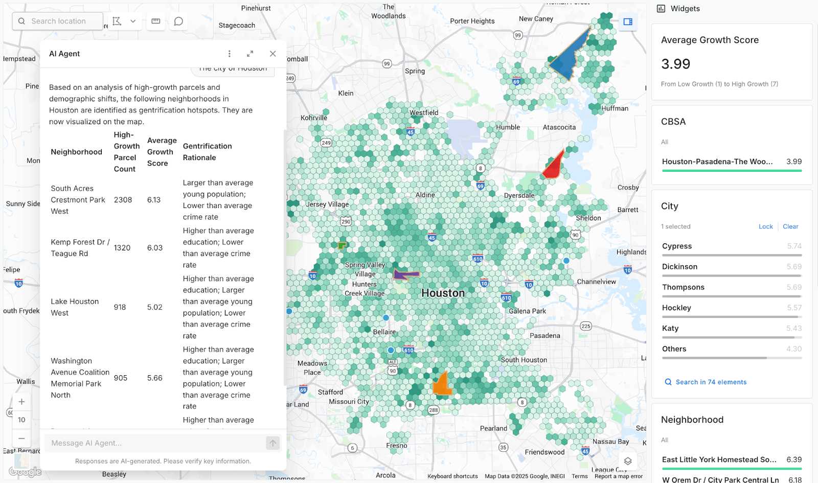
CARTO’s AI Agents directly query and analyze your spatial data where it already lives in the cloud, with all processing executed inside your governed warehouse. You can use your existing analysis pipelines - like workflows exposed as MCP tools - as callable building blocks. The agent handles the reasoning and orchestration, turning natural-language questions into secure spatial insights for anyone in the organization.
2. How does Agentic GIS differ from traditional GIS platforms?
Traditional GIS relies on specialists manually building and running tools and maps which are designed for very specific purposes. CARTO’s Agentic GIS platform leverages AI Agents, foundation models, co-pilots and MCP connectivity to automate workflows and make spatial insights accessible across the entire organization. GIS experts encode their knowledge into agents - so their best practices, validation rules, and analytical logic are amplified across the entire organization.
3. What types of geospatial tasks benefit the most from agent-led, iterative reasoning?
Tasks that require chaining multiple analyses - like site selection, hotspot detection, mobility analysis, or demographic enrichment - see the biggest gains. Agents can refine parameters, iterate workflows, and combine tools automatically until a meaningful result emerges. This makes complex, multi-step reasoning tasks far faster and more accessible to non-GIS users.