Turning Claude and ChatGPT into geospatial agents


Something fundamental is shifting in the way we build and use software. Not at the margins, but at the core. The rise of agentic AI platforms is changing how teams interact with data and analytical tools, and GIS is not going to be any different.
For decades, the standard interface for geospatial analysis has been a map-centric application: a specialist tool, requiring specialist skills, and accessed by specialists. That model may not be going away overnight, but it is giving way to something new. Agentic platforms — interfaces where users converse in natural language with an AI that reasons, plans, and acts on their behalf — are becoming a primary way for teams to engage with data and analytics. The GIS Specialist or analyst who once opened a legacy GIS desktop application may soon simply ask their AI agent to run the analysis. The data team that built spatial dashboards may soon find that the first place business users check isn't a dashboard at all, but a chat interface.
We believe this is one of the most significant platform shifts in GIS in decades. And we want CARTO to be the best place for geospatial analysis, for organizations to scale AI agents from whatever interface they choose.
This post gives an overview of the different ways CARTO is working to make that real: exposing geospatial workflows as tools that any AI agent can invoke, bringing interactive map visualizations directly inside conversations, and building a CLI and a set of Skills that allow agents to fully automate geospatial work on behalf of the user.
Geospatial workflows as MCP Tools
Last October, we launched the CARTO MCP Server, one of the first geospatial MCP implementations, and the starting point of our Agentic GIS strategy.
The core idea is straightforward: users can expose their CARTO Workflows, including data preparation pipelines, spatial analysis routines, and ML-powered predictive models, as MCP tools that any AI Agent can discover and call. Connect the CARTO MCP Server to Claude, ChatGPT, or any MCP-compatible platform, and those agents immediately gain access to a library of geospatial capabilities, customized to your data and your business logic.
This is meaningful for a few reasons.
- First, it preserves data governance: all computation happens inside the customer's data warehouse (BigQuery, Snowflake, Redshift, Oracle, Databricks, etc.), and data never leaves the governed environment.
- Second, the logic is transparent and auditable: agents aren't generating opaque SQL; they're invoking explicit, versioned workflows.
- Third, the scope of what's possible is substantial: with over 200 spatial components available through CARTO Workflows, agents can run analyses ranging from simple geocoding and buffering to complex multi-step site selection or catchment area modeling.
In practice, this looks like asking Claude to run a proximity analysis against a set of locations, or having a ChatGPT agent trigger a risk assessment workflow as part of a larger automated pipeline. The analysis happens in the data warehouse, CARTO provides the geospatial analysis capabilities, and the agent orchestrates it.
The map as part of the conversation
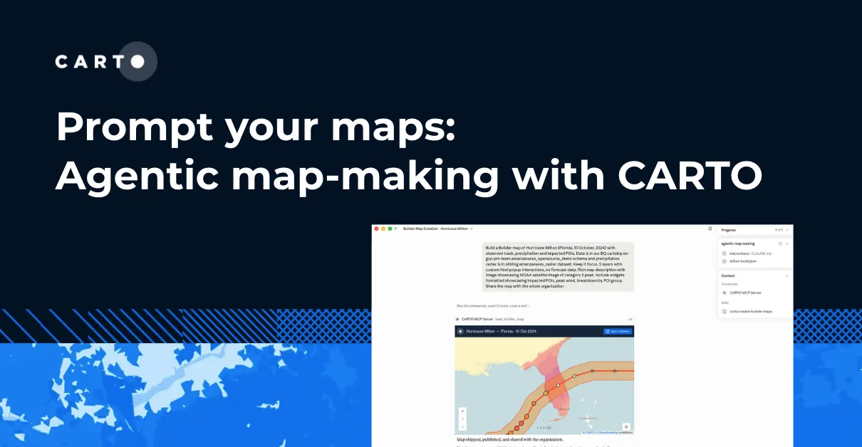
Text output from geospatial analysis will only take you so far. Knowing that 47 of your stores fall within a flood risk zone is informative. Seeing them on a map, clustered along a particular stretch of coastline, concentrated in zones shaded by risk level, is a fundamentally different type of understanding.
The recent introduction of MCP Apps as part of the MCP protocol changed what's possible here. Where MCP previously returned only text and structured data, MCP Apps allow servers to deliver rich, interactive interfaces directly inside the agent conversation. For a geospatial platform, this was the missing piece.
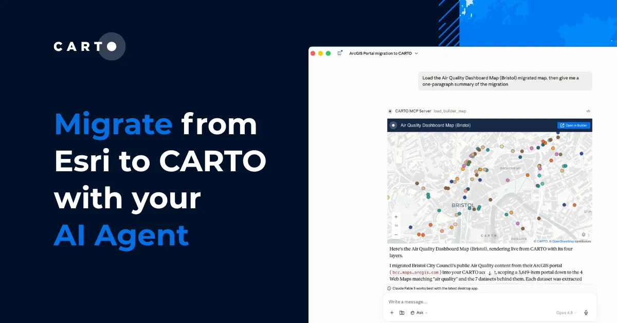
We've been building a prototype CARTO MCP App that does exactly this — render a fully interactive map powered by CARTO and deck.gl directly inside a Claude or ChatGPT conversation. Ask the agent to visualize a dataset, and you get a real map: pan, zoom, filter, hover. The data is queried directly from your warehouse and served as vector tiles, allowing you to explore millions of features interactively, without leaving the conversation.
Combined with CARTO Workflows, this becomes considerably more powerful.
💡 An agent can gather parameters from the user, trigger a spatial analysis, wait for results, and then return an interactive map, all within the same conversation thread.
Note: the CARTO MCP App is currently an experimental prototype and may change significantly as we develop it further. If you're interested in exploring it or learning what's on the roadmap, we'd love to hear from you.
The CARTO CLI and Skills for AI Agents
Geospatial analysis is rarely a single query. It involves multi-step workflows: preparing data, running analysis, iterating, reviewing, publishing. To support agents operating at that level of complexity, we need more than individual tool calls — we need agents that understand how to work with CARTO end-to-end.
Earlier this year, we released the CARTO CLI, a command-line interface designed from the ground up for organizations and AI Agents. Today it enables automated management and administration of CARTO accounts: promoting maps between organizations, querying usage analytics, configuring connections, all scriptable and machine-parseable. For AI Agents, the CLI provides a reliable, non-interactive interface with structured JSON output, composable operations, and headless authentication, exactly what agents need to safely operate autonomously.
We're pairing the CLI with Skills: curated instruction sets that teach AI Agents not just what CARTO can do, but how to do geospatial analysis with it. Think of them as domain expertise that agents can load on demand, the equivalent of onboarding an AI agent the way you'd onboard a new team member to your spatial data stack.
The near-term horizon we're most excited about: AI-assisted creation of data preparation and analytical workflows. Rather than building workflows manually in the CARTO interface, users will be able to describe what they want to analyze in natural language, and an agent, guided by CARTO Skills, will help them build the workflow iteratively. Claude and ChatGPT become not just executors of existing workflows, but collaborative builders of new ones.
What the future looks like
What we're building toward is a world where anyone can do geospatial analysis, regardless of technical background. Not because the complexity has been removed, but because AI Agents navigate it for them.
In the near term, richer in-conversation experiences: multi-layer interactive maps, spatial aggregations, custom widgets, and advanced styling. All generated and iterated upon through natural language in Claude or ChatGPT without ever opening a separate tool.
Further out, agent-to-agent orchestration: an enterprise AI agent (a general-purpose assistant acting on behalf of a business team) calling a suite of specialized geospatial agents for different tasks: one for network analysis, one for risk modeling, one for territory optimization. The general agent delegates; the specialists execute; the user gets answers.
Underneath all of this, something more profound: agents that don't just run spatial analytics, but build organizational memory around them. Context graphs (living records of analytical decisions, precedents, and exceptions) that allow agents to reason not just from data, but from the accumulated decision-making of the organization over time. Geospatial analysis then improves the more it's used by the organization, because the context is being captured, structured, and made available.
We're just getting started. But the direction is clear, and the transformation is unstoppable. We can't wait to show you what's next.
Try it today
Ready to explore? Connect the CARTO MCP Server to Claude, ChatGPT, or any MCP-compatible platform and start running geospatial analysis directly in your conversations. Check our documentation to get started, or reach out to us to learn more about what's coming.