about us
Our story
Founded back in 2012, CARTO has become the world’s leading Location Intelligence platform - allowing hundreds of thousands of users to unlock the power of spatial analysis.
What is CARTO?
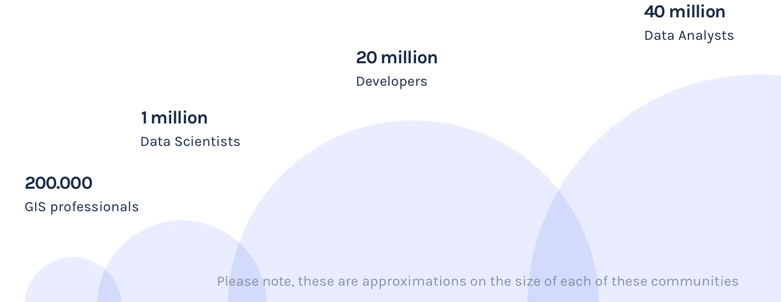
CARTO is the leading Location Intelligence SaaS platform empowering companies with cloud-native spatial
analytics. CARTO helps organizations make better business decisions by enabling data analysts, business
analysts, GIS professionals, and developers with scalable, faster, more flexible, and more secure spatial
data analysis and visualization tools.
Whether through optimizing network planning, assessing
risk, identifying growth opportunities, or other use cases, companies benefit from turning their location
data into business value.
RECOGNIZED BY:

LI Wave 2018

Cool Vendor

Member
Member

4.6 rated out of 5

Spring Leader 2023
Our story
CARTO began in 2012 when Javier de la Torre and Sergio Álvarez founded the company in Madrid. Their experience
in conservation and environmental projects revealed a critical need: better tools for analyzing and
visualizing large-scale location data.
While spatial analysis was essential for understanding
environmental challenges like biodiversity loss and climate change, the founders recognized its broader
potential. They saw that industries such as insurance, financial services, and telecommunications could
benefit from these tools, which had previously been inaccessible to many organizations.
The
platform grew rapidly, eventually reaching hundreds of thousands of users who use CARTO to solve problems
through spatial analysis.
Several key developments marked CARTO's evolution. In 2019, Luis
Sanz became CEO, and the company acquired Geographica to enhance its
spatial data science capabilities. In 2020, CARTO's
Data Observatory project received funding from the European Union's
Horizon 2020 research and innovation program, supporting its goal to build the world's leading spatial
data marketplace
Today, CARTO is headquartered in New York, with offices in Madrid and Seville. The
company employs over 160 experts in spatial analysis and GIS development. True to its innovative roots,
CARTO's team actively contributes to open-source projects, particularly in the
PostGIS community.
Our Mission
Historically, spatial analysis has been complex and siloed, restricted to a niche group of GIS experts.
However, as the field of spatial analytics grows and businesses strive to become spatially aware, the demand
for accessible Location Intelligence is increasing.
CARTO aims to bridge this gap and break down
the GIS data silo, enhancing the productivity of organizations globally.